Monday 23 July 2018

Returning to the Forest - Aviemore, June 2018

After our previous trip where we discovered a forest on the bottom of Lake Aviemore we were eager to return. With both of us having busy schedules, we managed to find a weekend that we both had free so we could make the trek back up to the lake for another dive. This time we knew what to expect and were keen to develop a solid plan of attack.

Before we could delve into the deep, dark depths of the lake we both had some new equipment to trial in the shallows. Once we had arrived on Friday evening we got straight into setting up our gear and drove down to Loch Laird, a small offshoot on the side of the lake. Upon getting out of the truck we got a bit of a shock: there was already frost on the ground! Oh well... we only needed to spend a few minutes in the water to make sure everything was OK. We slipped into our gear and entered the water. For me it was getting a feel for my new Jet fins and Adam was trying out his new Transpac and Apeks RK3 fins. We were both absolutely stoked with how they felt and performed so after little more than 5 minutes in the shallow 3m Loch we decided it was time to hop out. The fact that it was 5°C (41°F) water may have influenced the decision as well.
We rose bright and early eager to get out to the lake and get in the water. I made the mistake at looking at the outside temperature as soon as I woke and gave myself a bit of a fright... -3°C (27°F). I managed to convince myself that air temperature didn't matter and the water would be warmer. We made our final preparations checking lights, cameras, and housings. We went out to load up the truck and got a bit of a shock. Upon opening up the back of the truck we discovered that our gear was frozen from the previous night’s dive. Not something that we'd encountered before but not something we couldn't handle. We continued loading up and hit the road for the short drive to the northern shores of the lake.
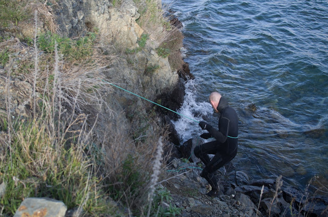
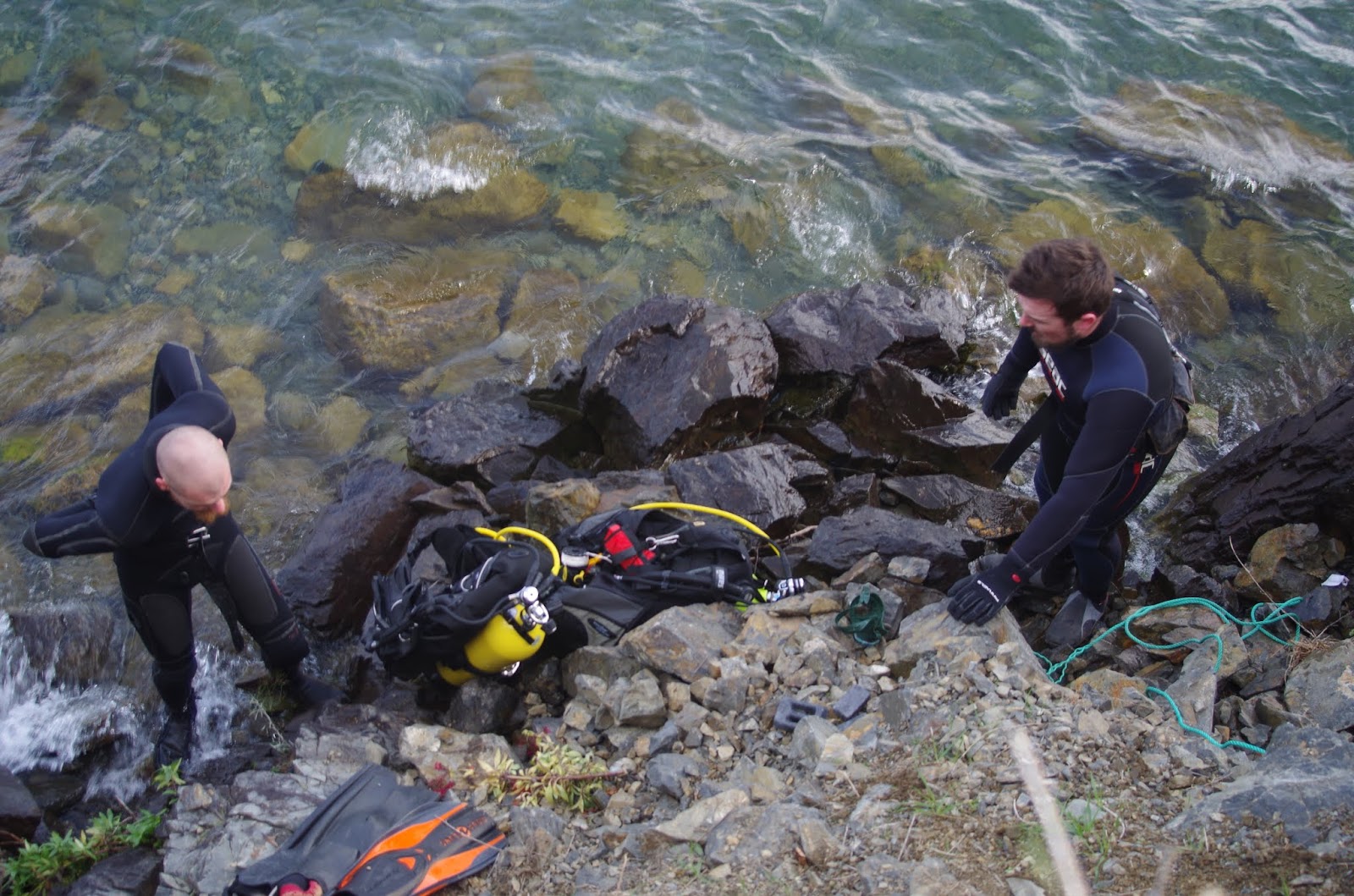
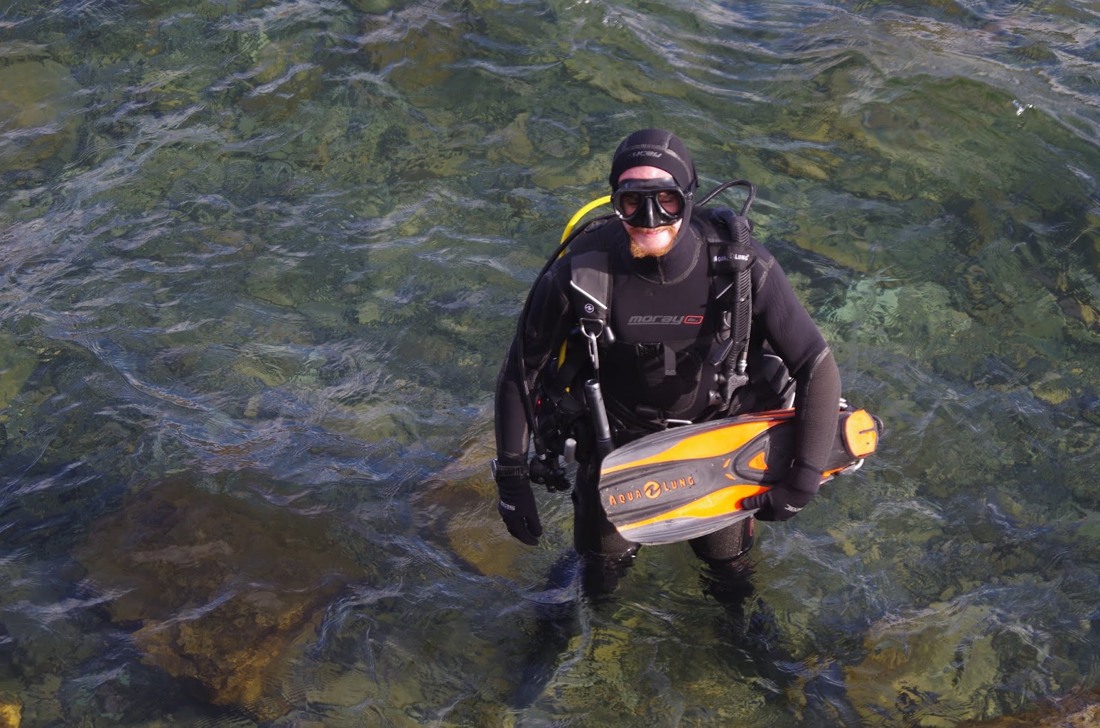
We arrived at our parking spot and quickly got the rope rigged up to get down the cliff to the waters edge. After figuring out what to do last time it was a much easier and smoother process. I abseiled down and Adam lowered the gear to me (it's quite easy when your buddy is the stronger one). After gearing up and recapping our dive plan we fired up the cameras and slipped below the surface. I'm not sure how it happens but I almost always end up leading while Adam follows, it works out well and we both end up happy (except when I make a mistake navigating). We slipped effortlessly into the depths passing a familiar boulder at 27m (90ft). Good, we're on the right track. Soon enough the bank flattened out and we were on the bottom. The forest drifted into view. It's an amazing experience drifting almost silently through the branches. Your mind slips 50 years into the past, imagining what the valley would have looked like before it was flooded all those years ago. Time slipped by quickly as I snapped a few photos of the forest and Adam. Soon enough we hit our limits and it was time to return to the surface. We made our ascent, shooting my surface marker on the way and completed our required decompression of 4 minutes at 6m (20ft). It was only upon reaching the surface that the cold truly hit us. We had intended to make a second dive later in the day but even before reaching the shore we knew that was not going to happen.


We then headed back to the bach for some warmth and started to work on the plan of attack for the mornings dive. Since we knew what depths and distances we would encounter our planning process was pretty straightforward. Utilising our TDI Decompression Procedures training in conjunction with Suunto DM5 planning software we developed planned and contingency schedules for both our dive profile and gas management. We settled on a plan of 15 minutes bottom time at 36m (118ft) which fitted nicely with the gas we had available whilst minimising our required decompression stops. With the dive planned and cameras charged we slipped off to bed ready for an early start in the morning.


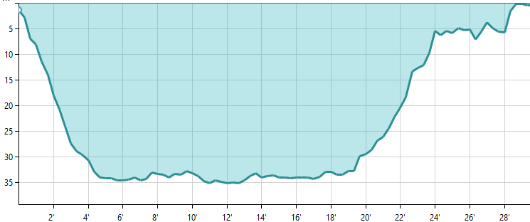
Dive Profile. Runtime: 29 min, Max depth: 35.2m (115ft)

Getting the gear up the cliff was a little bit of a challenge this time. Adam was more than capable of the physical lifting but for me it was a rather difficult to tie the gear to the rope with my frozen fingers. Miraculously my knots held and the gear made it up the cliff. After Adam had hauled the last of the gear up it was my turn to clamber up and we quickly changed out of our wetsuits before driving back to the bach. It was only after we had thawed ourselves thoroughly that we thought to check what the bottom temperature actually was. The previous month it had been 9°C (48°F) and the previous night in the Loch had been 5°C (41°F) so we thought this would be the coldest it would be. Nope... 3°C (37°F) on the bottom this time. No wonder we were cold. 


Despite only making one dive to the forest it was still a great trip. Now it's time to get the drysuit fixed, sort out some better camera lighting, and finally get set up with doubles to extend our bottom time. We'll get there eventually.

Here's a selection of photos from the dive:


Friday 8 June 2018

Trip Report: Aviemore, May 2018

As will soon become apparent one of my favourite spots to dive is Lake Aviemore in the Waitaki Valley of New Zealand. It's not the typical spot that people would dive but it works for me. As far as me and Adam, my main dive buddy, can tell we're some of the only, if not the only, people that head up there to dive. This means that we get an immense feeling of exploration on every dive. We may be the only people that have seen what lies on the bottom of the lake since it was flooded as a hydro dam back in the 1960s. Pretty cool isn't it?

So when it came to my birthday weekend this year it made sense to head up to Aviemore for a little bit more exploration. We had recently got our hands on a bathymetric chart of the lake showing us what depths we could expect throughout the main section of the lake. Armed with this knowledge we set off with two goals for the weekend. Firstly we wanted to do a dive on my birthday and secondly we wanted to explore one of the deeper sections of lake that we had identified on the chart.

The first goal was relatively easy to achieve. Well we thought it would be. We had planned to do a night drift dive along a section of lake known as the Aviemore river. This section sits just below the Benmore dam and is only 50-100m (160-330ft) wide and has a fair amount of current flowing through it. Our intention was to make our way to the lake after work and do our dive as soon as we got there. Unfortunately, one of us, who shall not be named, forgot a key piece of diving equipment and had to turn around and head back home to get it. This meant that we weren't both at the lake until around 11pm. No big deal a night dive is meant to be done in the dark anyway. So with both of us up at the lake we prepared our equipment in the garage and loaded everything into the car before donning our wetsuits and driving down to the lakes edge. One of the great things about drifting the Aviemore river is the ease of access. It's one of the only spots I know of that you can do a shore dive that's also a drift dive and guarantee that you'll exit in the right spot. This means we can drop off our gear at our entry point and then drive the car down to the exit point before walking the 20 or so minutes back to the entry point. We entered the water noticing that the lake level was a little lower than usual. I took the float and led the dive and  all the worries of surface life disappeared. We had a plan to move a little further out from shore into deeper water than usual to explore some new areas of lake. This didn't seem to be paying off initially until we found something totally unexpected. We knew there was remnants of an old bridge in there somewhere but I had never seen it myself. This dive changed that. Out of nowhere an immense hunk of steel emerged from the darkness. This continued for a fair while as we swam over and around this structure that seemed out of place in an underwater environment. After the bridge it was more of what we were used to. A few trout and salmon swimming around but too easily spooked to be photographed. We then made it to the shallows that marked our exit point. We followed the slope up and exited the water. A massive sigh of relief was had when we saw the car parked only 50m away. Out of the water we headed back to the bach (Kiwi term for holiday home) and broke down the gear, rinsed the wetsuits and began our planning for the next day.
Dive profile for night drift
Approximate path followed
It's not a trip report without a fish photo right?

Saturday came around and it was time to get serious about finding the deeper spots of the lake. We had tried previously but hadn't quite found the right spot. This time we spent a lot longer looking over the chart and ensuring that we would have exact coordinates for our entry point. Luckily I could remember enough from my skippers ticket training to do a bit of chartwork and figure out some coordinates we could follow using the GPS on our phones. Given that these coordinates had to be converted between a number of different systems and that I had used pieces of paper instead of parallel rules I was dubious about how accurate they actually would be. Adam had faith in me so again we prepped the gear in the garage loaded up the car and made our way to the coordinates we thought were right. When we arrived everything matched up with what we expected so we began the final preparation for the dive. We had one minor obstacle to overcome before we could slip below the surface and enjoy the dive. Whilst there was ample room to park and prepare the gear next to the road the edge of the lake was about 3m below the road down a rocky cliff. No problem we're kiwi's and we can overcome this we thought. Adam found us a rope in the car which I tied off the tow bar of the car to enable me to abseil down the cliff to the waters edge. Once I was safely down the cliff Adam pulled the rope back up and we began the slow process of lowering the gear down piece by piece. I have to say I was a little bit concerned about Adam's knot tying abilities (he doesn't know this) but he well and truly proved he can tie knots that work. They're knot pretty but they work (sorry Adam!). Then it was Adam's turn to abseil down and we slipped into our gear, reviewed the plan, and disappeared below the surface. 

Almost immediately we knew we in the right spot. A steep sloping bottom led us into the depths of the lake. At around 28-30m we encountered a flat section of bottom for 20m or so which then dropped steeply to our max depth of around 36m. We now believe that flat section was an old road or something similar from before the lake was flooded. At our max depth initially it seemed that whilst we had found the depth and location we wanted it was just going to be a silty bottom with nothing else to see. This soon changed as we swam a little further and out of the gloom emerged a forest of leafless Willow trees. This confirmed that we must have found the old riverbed which also meant we were likely to be the only people to see these trees since 1968. We explored swimming between the trees for a few more minutes before we reached our gas limits and turned to head for the surface. We had a pretty uneventful ascent, completed our safety stop, and surfaced a short surface swim from our exit point. We couldn't get out of the water quick enough, partly because it was rather cold but mainly because we were bursting with excitement. We'd been wanting to find this spot for a while and to have finally done it was an amazing feeling. Getting out of the water it was basically the reverse of getting in. Adam climbed first, I tied the gear to the rope and Adam hauled it up. Once all the gear was up I climbed up and we quickly removed our suits and made our way back to the bach. 
Adam checks out the chart before the dive
 Abseiling down the cliff
 Adam lowers gear down
 Gearing up on the edge of the lake
 Entering the water
 All ready to go
Such great spot to dive
Dive Profile
Area explored

Before we had made it back to the bach we were already planning our next trip to this same spot. We had chosen not to take cameras on this dive as we had very little idea of what to expect and wanted to enjoy the dive rather than taskloading ourselves. We will definitely be back at some point to film, photograph, and map what is down there. Since this trip I have been searching for old records of the area and have found a number of maps that show what the terrain was like before the lake was flooded. I am interested to see how these compare to what we actually experience down there.

Thanks to Adam for being a great buddy and Emma for the surface support and photos.